

How the Cold War Ended 3
Glasnost, Perestroika & the Wyandot

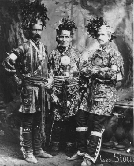
(Huron-Wendat Chief Elie Sioui [1798-1884] flanked by his sons Honoré and Elie Jr., around 1880. Archives nationals du Québec)
The farmland on which Gorbachev and Yakovlev had their fateful walk in May 1983 has a rich history — one obscured by the sands of time and tides of settlement over nearly two centuries. It is associated with peoples — today’s Huron-Wendat and Wyandot — who shaped Canada from the start. It also illustrates the many ways in which the paths of Canada and Russia have jarringly diverged.
From 1836 to 1998, the farmland on the Detroit river on which these Soviet leaders walked was part of Anderdon township, a municipality formed out of the territory of the former Huron Reserve. In 1790, deputy Indian agent Alexander McKee reserved this land as part of treaty number 2, also known as the McKee Purchase.
By this agreement, whose text runs to only six paragraphs, “the principal Village and War Chiefs of Ottawa, Chippawa, Pottowatomy and Huron Indians Nations of Detroit” surrendered much of what is today southwestern Ontario to the crown, while reserving two areas for First Nations.
Treaty number 2 was signed by 34 chiefs: eight Ottawa, seven Chippewa and six Potawatomi, as well as thirteen from the Huron or Wyandot nation.
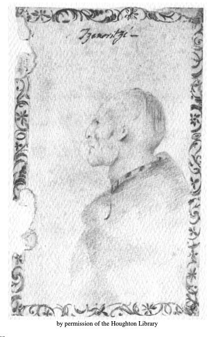
(Sastaretsi as sketched in 1778-79 by British governor of Detroit Henry Hamilton)
Among the Wyandot were the hereditary chief known as Sastaretsi, who had been sketched by British governor Henry Hamilton in 1778-79 at Vincennes — just before it fell to the Americans — when Sastaretsi was about 38. (Hamilton called him ‘Tzenoritzi’.) By 1790, when treaty number 2 was signed, he was about 50.
A book by Wyandot author and activist Peter Clarke described the role still played by this Sastaretsi in the years after the signing of treaty number 2:
“About this time the King, or Head Chief of the Wyandotts, Sut-staw-ra-tse, called a meeting at the house of Chief Adam Brown, who had charge of the archives, for the purpose of overhauling them, which consisted of wampum belts, parchments, &c, contained in a large trunk. One by one was brought out and showed to the assembled Chiefs and warriors.
“Chief Brown wrote on a piece of a paper, and tacked it on each wampum belt, designating the compact or treaty it represented, after it had been explained from memory by the Chiefs appointed for that purpose. There sat, before hem, their venerable King, in whose head was stored the hidden contents of each wampum belt, listening to the rehearsal, and occasionally correcting the speaker, and putting him on the right track whenever he deviated. Here was an accumulation of documents during a period of about seventy years, and which took them two or throe days to examine and rearrange them all in proper order. (…)
“The old Head Chief, who presided on this occasion for the last time, was the last lineal descendant of his race of pure Wyandott blood; and whose lamp of life went out at the close of this dccade (between the years 1790 and 1801). Not one can be now found among tho remnant of his nation, but what are either mixed with the whites, or with Indian blood of other tribes.”
The McKee purchase was driven by the need to accommodate indigenous and loyalist settlers on the Canadian side of the Detroit river given the stark reality of a new border with the United States. Under the terms of the 1763 Royal Proclamation, no land could be granted for settlement without negotiated treaties with First Nations. In practice, vast tracts were made available for America and European settlers. Only two small but strategically positioned areas were set aside for indigenous groups.
The first was a triangular strip of land, just over 1,000 acres, located around the ‘Huron church’. This was the oldest continuously operating Roman Catholic parish in Ontario, begun in 1728 as the Mission des Hurons de la Pointe de Montréal du Détroit on the north side of the Detroit river, in today’s state of Michigan.
This mission church moved to the south, Canadian side in 1747. By the early 1780s, it had become known as la paroisse de l’Assomption. The main parish in the area — Ste Anne de Détroit, founded on July 26th, 1701 — remained in the US.
After Fort Detroit itself was handed over in 1796, this Huron mission tract on the Canadian side, reserved for First Nations under the 1790 McKee Purchase, was itself surrendered to the crown. It became ‘old Sandwich town’ – a new British administrative centre, first surveyed in 1797, to replace Detroit.
The deed transferring this land to the crown was signed in September 1800 by McKee’s son. Nineteen chiefs drew their totems on the document for the Three Fires Confederacy (Ottawa, Potawatomi and Chippewa) and the Wyandot nation.
The larger tract reserved for Indian allies in 1790 comprised over 23,000 acres. Known as the ‘Huron Reserve’, treaty number 2 defined it as follows: “Reserving a Tract beginning at the Indian Officers Land at a small run near the head of the Island of Bois Blanc and running upwards along the border of the Streight to the beginning of the French Settlement above the head of the Petite Isle au D’Inde; then a due East line seven miles and then South so many miles as will intersect another East line run from the mouth of said Run or Gully near the head of said Island of Bois Blanc.”
The ‘Indian Officers Land’ was further south, around Fort Amherstburg, established in 1797 to replace the military headquarters at Detroit. Because the area around it later became the township of Malden, this new British military outpost was also known as Fort Malden — even after it was burnt down by American forces at the end of their 1813-15 occupation of the area.
Up to the 1830s, Amherstburg was a major centre for the British Indian department whose officers — relocated from around the Great Lakes after 1796 — received land in the area. These included George Ironside, Simon Girty, Matthew Elliott, William Caldwell, Prideaux Selby and others.
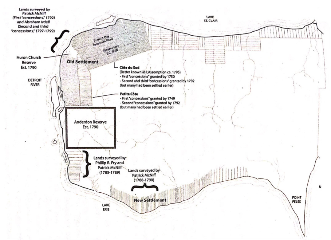
(Map outlining the layout of the Windsor region after the McKee Purchase in 1790 from Tarisa Dawn Little, “To Those Who Say We Are Assimilated, I Say Hogwash!'“: A History of the Wyandot of Anderdon Day School Experience, 1790 to 1915’, p. 87. This map was reproduced from Guillaume Teasdale, “Map of Essex County, 1795,” in Fruits of Perseverance: The French Presence in the Detroit River Region, 1701–1815 [Montreal: McGill-Queen’s University Press, 2019])
